Milestones, Boundary Markers, Historical Artifacts, Street Furniture, lost roads and buildings.

There are many traces of our ancestors scattered around our landscape. Mile Markers and Boundary stones are there too. The Milestone Society believes that there are approximately 9000 left in the United Kingdom. Some are cherished but others are hidden in hedgerows, some have been unwittingly destroyed by crashes, road equipment or even stolen. Roads have been straightened to make them safer. There are old gateposts still left in place, old buildings, and place names that declare an evocative past. The aim is to capture some of this information at least photographically before it disappears.

Although the Fylde Coast does not have ancient history, the Romans apparently struggled to Kirkham. There have been huge changes in the last two centuries from literally a a few fishermans' and agricultural dwellings, to a full blown tourist and light engineering industry.

More historical information can be found here about the Fylde coast.

It also seems that time has marched on and left what appears to be some very respectable buildings... which just should be used, but seem to have no worth.

Links from this Blog

Nearly-Midnight The genealogy website relating to the family. A tangled web of people all related to one another, explore!
Memorials Website dedicated to War Memorials - The majority in the North of England. Visits to churches, but also memorials in out of the way places.
Robert Clark The Father of Henry Martyn-Clark - A missionary out in the North-West Frontier of India. One of the first Europeans to set foot in Afganistan
Affetside Census
A small village north of Bury, Lancashire, I can trace many of my immediate ancesters from there. On the Roman Road, Watling Street
Andrew Martyn-Clark My Father and his part in my World. Also my mother and his parents too.
Henry Martyn-Clark My Great Grandfather, his roots and his achievements. Discusses malaria but also his confrontations with Islam.

Monday, 6 May 2013

Samuel Ladyman drinking Fountain

Samuel Ladyman - Author: His observations of his Keswick life were entitled "
Thoughts and Recollections of Keswick and Its Inhabitants During Sixty Years (1885)" A facsimile is available from Amazon. This fountain is just below the Toll Cottage on the previous post.
Samuel Ladyman Drinking Fountain, Chestnut Hill

The Plaque reads:
"Drinking Water Fountain
One of Four Erected Circa 1875
Cleaned and Marked by
Keswick Civic Society 2003"
Born on 26 Dec 1812 to Thomas Ladyman and Mary Wharton. Samuel married Isabella Dixon and had 2 children. Samuel married Jane Routledge. Samuel married Mary Wharton. He passed away on 31 Jul 1885 in Crosthwaite, Cumbria, England. Here is a link to another. I wonder where the other 2 are. 


Toll Bar Cottage, Chestnut Hill, Keswick

Having got lost! again. Heading down the Castlerigg road seemed to be a good idea. I had to get to Keswick. Spotted this building. This is a really steep bit of hill. A good place to have a toll. I would suggest it is on what would have been the "main" road between Keswick/Penrith and the south. The next village of any significance will be Grasmere, then Ambleside. There is a little more info here. The toll roads are under researched and little known part of our heritage. The cottage is situated on a fork of the road. This site gives a little more information about  the cottage.

To the right of the cottage is the Penrith Road
The slope is fairly obvious

Looking from Keswick, up the Ambleside Road
The Samuel Ladyman Water Fountain is seen just to the left.
The road forks. The right fork heads off to Grasmere and the left to Penrith
 There was no competition for this Toll Road. There was no canal travel and the railways did not go this way.


Sunday, 5 May 2013

Pickering - Smiddy Hill

I walked into Pickering - this is the first part of Pickering that I really took an interest. There are some grand houses on the approach road too. I was to visit the wonderful church, the castle, and the railway too; but these will be another page.

John Wilson - Water Fountain

John Wilson Water Fountain
Cross behind and the church behind that

The inscription on the cross

The Cross with the Liberal Cub behind

The sensory garden, the cross - the John Wilson Fountain is just behind the cross.

Make no apologies for the panorama. IOt shows the Church, the cross and the water fountain.

I am pasting the 2009 Pickering Town council Newsletter below; Apologies about any copyright breeches - please copy and use the images if you wish. The panorama has already been published once.

Smiddy Hill
The Town Council is responsible for the two open spaces in the town centre,
Riverside Walk and Smiddy Hill. Some years ago, at Riverside Walk, the Town
Council created an amenity area from what had become an eroded bankside. The amenity with retaining wall, trees, small scale planting, seats and picnic tables is enjoyed by local people and visitors alike.

Smiddy Hill is also an area in the town centre where people can rest awhile. In the
centre of the open space is a cross which commemorates the reign of Edward VII
and the accession of George V. There is another memorial at the southern end to the late John Wilson. The deceased was a local councillor – he served on both Pickering Urban District Council and the County Council - and a member of the Labour Party. This memorial was erected in 1950. The only other structure is a raised sensory garden in front of the Liberal Club.

A small group of local people chaired by Councillor Margaret Lowe has been look-
ing at the open space at Smiddy Hill will known as the Lumley Rest Gardens. The group has come up with a series of recommendations which the Town Council is considering. The main recommendation is that the lower shrub bed and attendant railings are removed. This would open up Smiddy Hill from the south and show the
commemorative cross, backed by the buildings on the north side of Smiddy Hill, to better effect. The flower boxes at the base of the cross would be removed so that
the structure could be seen as a whole. The shrubbed area would be turfed and the seats which run along its top side moved to the eastern side of the open space. In addition the Wilson Memorial would be re-erected in the cemetery where the remains of John Wilson are buried. It has proved very difficult to make the memorial vandal proof: the tap has had to be replaced regularly and no longer can water run freely into the lower basin where it used to be available for dogs and birds. The lead inscription has suffered much wear and tear and hardly any of the lettering remains.

Grounds maintenance is undertaken by the Town Council with Pickering in Bloom and the Council is particularly grateful for the work that the In Bloom group has done with Pickering’s young people in creating floral displays in the open space. The Town Council hopes that this will continue and is also grateful to the In Bloom group for being willing to recreate the sensory garden.

The Town Council would not only appreciate any information you might have about the history of Smiddy Hill once it ceased to be a cattle market in the late nineteenth
century but also on the ideas for change.


Saturday, 27 April 2013

Blackpool - the gateway

Two panoramas from Rigby road bridge!

From the top of the bridge looking towards the sea. This bridge originally carried the railway line but now carries car traffic into central car parks.
The bus depot is on the left, I worked on the buses for a season too! the remains of the gasometers is on the right. This takes you all the way to Manchester square.

Rigby road going inland. The buildings on the left are situated on the old rugby stadium which doubled as a dog track(Bugsy). I used to train there. Never could catch those bloody dogs. However the walls around the ground are the original ones and still in good condition. I can recall a bus driving into the bridge one evening - taking a short cut back to the depot!

To the right is where the old illuminations depot was, just behind is where the Mecca used to be and to the right is Bloomfield road home of Blackpool FC. EVERYTHING in this picture has changed in 20 years. At least the close stuff. If you enlarge the picture the big building left of centre is Revoe library.

I applied for and got the job as a programmer at the illuminations department. The buildings were shared with donkeys - good job, but the smell!


More gateway pictures but this time from Waterloo Bridge in South Shore.

The top of Waterloo Road bridge Looking north. Waterloo road is on the extreme right heading downhill with the ambulance station on the right. The climbing walls are visible in the centre  of the picture. The Graffiti on the wall at the left is the cinema end wall
A Clser view, actually taken with a wider lens. This was a Friday afternoon in mid May. Surprised the car parks are empty. Blackpool Tower is dead centre.

The other side of the bridge. The road running through the bridge reappears on the picture above as the upper road. This road (Yeadon Way) eventually joins the M55
Very similar shot to the two above, but at the left side of the bridge. Shows empty car parks.

The end of the line - literally. This is South Shore station. A single track heads towards Preston via Lytham. The rail track used to run to central station, long since demolished. The road in the distance is Yeadon way which joins the M55.


Lots more information on our wonderful town 

The Elba Monument and Milestone

Saw this a few years ago when I visited the Burneside papermill and also "did" the Skyline event with Morecambe bay and Bowland LDWA. Never photographed it.

Situated on private land and slightly off the beaten track (A591), it is imposing. Seems in good condition too. There is a better explanation of the monument here.

Monument hill, leaning over the hedge!

The milestone is almost directly below the monument. This is on the original A591. The road was straightened and this is on the dog leg that was left.

Kendal 2 miles

Windermere 6 miles

Looking head-on a benchmark can clearly be seen.
The metal pin is just visible. There has been wear on this stone.

Friday, 15 March 2013

Milestone at Castlerigg, Keswick

I missed my turn off when descending from Walla Crag and found this milestone.
It has the reference CU_KWWM01 in the milestone database.
Here are the 3 shots!
Close-up looking towards Keswick

Looking up the Ambleside road

Close up looking up the road


Sunday, 13 January 2013

Marton Drive Library, Blackpool

This library was my local library when I was in my 20's. I went in their fairly regularly, frequently a stop with one of the kids in the buggy. There wern't plenty of books but it had quite a goods kid's section and there was a reading room full of old codgers sheltering from the cold. It has looked like this for a couple of years now. Shame nice memories, but there just does not seem to be a future here.

The entrance to the library on Marton drive.
It is halfway between Spen Corner and the Oxford.

The boarded up entrance

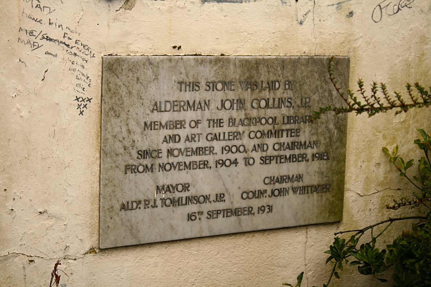
THIS STONE WAS LAID BY
ALDERMAN JOHN COLLINS J.P.
MEMBER OF THE BLACKPOOL LIBRARY
AND ART GALLERY COMMITTEE
SINCE NOVEMBER 1900, AND CHAIRMAN
FROM NOVEMBER 1904 TO SEPTEMBER 1918

MAYOR ALDERMAN R.J.TOMLINSON J.P
CHAIRMAN COUNC. JOHN WHITTAKER
16TH SEPTEMBER 1931.

Circular window close up
The Fir Grove end. This is facing down Marton Drive
to the Spen Corner roundabout

Showing the rear of the building.

Another view of the Fir Grove end

From across the road


Thursday, 27 December 2012

The Old Bank - Warley and Dickson Road, Blackpool

Decus Prudentiae Merces(Honour is the reward of prudence)
 
Oh no! he's gone all Latin again. Actually its on the crest of the NatWest bank at the corner of Warley road and Dickson road. Got to own up it looks really out of place on the corner. However it is a symbol of a bygone age. Fine piece of stone work, especially the crest. Destined to be flattened, may even have been by the time you read this. The pictures together with some descriptions, followed by excerpts from the planning documents.I knew it as a NatWest Bank, but maybe this building's history starts here.
Close up view of the crest above the main door.
The perspectives have been straightened in Gimp

Looking down Warley road from the front entrance.
The brick building is the Hilton Hotel formerly known as the Pembroke hotel.
I feel that some of this metalwork, concrete may have survived the demolition of the Derby Baths


The Hilton Hotel. It sits where the Derby Baths used to be.

The Hilton is to the right, on top of the the wall sits the "Old Bank"
Looking down the other side of Warley road.
Threre was a bloke in one of the windows watching me intensely.
What he thought I was up to who knows.
The church building is the Kings Christian Centre


View from Warley Road. This is side of the "Old Bank"
The Derby Supper Bar is across the Dickson road.
Members of my family have worked there in the past.


From the lower end of Dickson road. The main entrance is clearly visible.

The same shot but a slightly wider angle. The Hilton is behind.
Close up of the crest above the door.

Looking down Warley road. The church is visible in the background.

The close up of the front of the building. The entrance is set at an angle.

Slightly wider view of the "old Bank"

Looking past the bank towards Gynn Square
The side of the bank

Derby Supper bar on the right, Bank on the left looking towards the Gynn

Looking towards the town Centre.
The Pembroke(Hilton) is on the right.
Blackpool Tower is in the distance. The town centre is about 3/4 mile away.

The Hilton Hotel from the back. It occupies the same site as Derby Baths.
(No real objection to that being flattened!)
The Steel framed building going up.
Possibly see just the back of the Hilton

Same shot!

The antique shop that has faced the Old Bank for well... decades

Looking down Dickson road to the Gynn roundabout

Still looking down from the other side of the road.
The ownership of many of the properties has changed. Not sure where the Derby Supper bar is/was any-more!


Beneath are some excerpts from the planning permission documents:


PROPOSAL:
Erection of single storey retail store (Use Class A1) including vehicular access from Dickson Road and egress onto Warley Road and provision of 12 car parking spaces and servicing area, following demolition of existing building and associated changes in land levels.

LOCATION:
THE OLD BANK, 35 WARLEY ROAD, BLACKPOOL, FY1 2AG


The site is that of the 'Old Bank' which has a site area of 920 sqm and is located on the prominent south-west corner of the junction of Warley Road and Dickson Road. It has a frontage of 28 metres to the former and 33 metres to the latter. The land to the north and west of the site slopes away making the application site the highest point in the immediate area. These varying land levels further emphasise the site's prominence within the wider streetscene and make it highly visible from all sides. The existing single storey building sits adjacent the Dickson Road footway but is set back from the Warley Road frontage by approximately six metres. There is currently a single useable access/egress point on Dickson Road and a car park to the rear of the building.

The site is within the Defined Inner Area and Resort Neighbourhood and sits adjacent the Dickson Road Local Centre, as designated in the Blackpool Local Plan 2001-16. Although it is not part of the centre itself, the properties immediately to the north and east on Dickson Road do fall within the Local Centre. To the south and west of the site are grounds belonging to the Hilton Hotel. The building has previously been used as an advertising agency, and a bank prior to this (both uses are Use Class A2). In recent years the building has been vacant.

 
Following the demolition of the existing building (approximate gross floor area of 180 sqm) the proposal involves the erection of a single storey retail store (Use Class A1) which will occupy the north east corner of the site, sitting adjacent the footway on both Dickson Road and Warley Road. The new building has a Dickson Road frontage that will be 25 metres long, a width of 17 metres and will be a similar height to the former bank (5 metres high at the north east corner). The external elevations consist of a mixture of brickwork, cladding and a high proportion of glazing to the east elevation. The gross internal area is approximately 380 sqm which equates to a retail floor area of 243 sqm. Refuse, loading and storage areas are located to the rear of the building. An ATM will be installed in the south elevation of the building. Currently, the opening hours and staff levels are not known.

 
Blackpool Civic Trust - the existing building is of local and historic architectural significance and also sits well with other properties in the area. For these reasons the existing building should be saved.

Built Heritage Manager - the building is of local architectural interest and is in a prominent corner location. Historic buildings are non-renewable assets and should be recycled by finding a new use, whilst demolition and rebuilding is not a sustainable form of development. Furthermore, as the proposed design does not contribute to the architecture in the area it does not justify the demolition of the existing building.

Design and appearance - the existing building is on the draft Local List and it is recognised that it has some architectural merit. However, it is important to note that this local designation does not offer the building any form of protection against demolition by a developer. It should also be noted that the building has not been in continuous use since it was vacated by the Bank and that this may reflect its lack of versatility to accommodate other uses. Given it is an isolated building and there are other examples of this type of building in the town its loss is not considered significant having regard to paragraph 135 of the NPPF. For these reasons, a new build development is considered appropriate and unavoidable at this time.

Summary - the principle of a retail use at this site is considered appropriate given its relationship to the existing centre (and its previous commercial uses) and it is not felt that the proposal would unduly impact on visitor or residential amenity, or highway and pedestrian safety. Furthermore, the proposal will bring new development to the area, helping to regenerate it by creating jobs as well as bringing a vacant site back into use.

So just a matter of time before TESCO moves in!