Milestones, Boundary Markers, Historical Artifacts, Street Furniture, lost roads and buildings.

There are many traces of our ancestors scattered around our landscape. Mile Markers and Boundary stones are there too. The Milestone Society believes that there are approximately 9000 left in the United Kingdom. Some are cherished but others are hidden in hedgerows, some have been unwittingly destroyed by crashes, road equipment or even stolen. Roads have been straightened to make them safer. There are old gateposts still left in place, old buildings, and place names that declare an evocative past. The aim is to capture some of this information at least photographically before it disappears.

Although the Fylde Coast does not have ancient history, the Romans apparently struggled to Kirkham. There have been huge changes in the last two centuries from literally a a few fishermans' and agricultural dwellings, to a full blown tourist and light engineering industry.

More historical information can be found here about the Fylde coast.

It also seems that time has marched on and left what appears to be some very respectable buildings... which just should be used, but seem to have no worth.

Links from this Blog

Nearly-Midnight The genealogy website relating to the family. A tangled web of people all related to one another, explore!
Memorials Website dedicated to War Memorials - The majority in the North of England. Visits to churches, but also memorials in out of the way places.
Robert Clark The Father of Henry Martyn-Clark - A missionary out in the North-West Frontier of India. One of the first Europeans to set foot in Afganistan
Affetside Census
A small village north of Bury, Lancashire, I can trace many of my immediate ancesters from there. On the Roman Road, Watling Street
Andrew Martyn-Clark My Father and his part in my World. Also my mother and his parents too.
Henry Martyn-Clark My Great Grandfather, his roots and his achievements. Discusses malaria but also his confrontations with Islam.

Saturday, 27 April 2013

Blackpool - the gateway

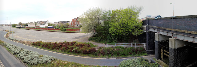
Two panoramas from Rigby road bridge!

From the top of the bridge looking towards the sea. This bridge originally carried the railway line but now carries car traffic into central car parks.
The bus depot is on the left, I worked on the buses for a season too! the remains of the gasometers is on the right. This takes you all the way to Manchester square.

Rigby road going inland. The buildings on the left are situated on the old rugby stadium which doubled as a dog track(Bugsy). I used to train there. Never could catch those bloody dogs. However the walls around the ground are the original ones and still in good condition. I can recall a bus driving into the bridge one evening - taking a short cut back to the depot!

To the right is where the old illuminations depot was, just behind is where the Mecca used to be and to the right is Bloomfield road home of Blackpool FC. EVERYTHING in this picture has changed in 20 years. At least the close stuff. If you enlarge the picture the big building left of centre is Revoe library.

I applied for and got the job as a programmer at the illuminations department. The buildings were shared with donkeys - good job, but the smell!


More gateway pictures but this time from Waterloo Bridge in South Shore.

The top of Waterloo Road bridge Looking north. Waterloo road is on the extreme right heading downhill with the ambulance station on the right. The climbing walls are visible in the centre  of the picture. The Graffiti on the wall at the left is the cinema end wall
A Clser view, actually taken with a wider lens. This was a Friday afternoon in mid May. Surprised the car parks are empty. Blackpool Tower is dead centre.

The other side of the bridge. The road running through the bridge reappears on the picture above as the upper road. This road (Yeadon Way) eventually joins the M55
Very similar shot to the two above, but at the left side of the bridge. Shows empty car parks.

The end of the line - literally. This is South Shore station. A single track heads towards Preston via Lytham. The rail track used to run to central station, long since demolished. The road in the distance is Yeadon way which joins the M55.


Lots more information on our wonderful town 

The Elba Monument and Milestone

Saw this a few years ago when I visited the Burneside papermill and also "did" the Skyline event with Morecambe bay and Bowland LDWA. Never photographed it.

Situated on private land and slightly off the beaten track (A591), it is imposing. Seems in good condition too. There is a better explanation of the monument here.

Monument hill, leaning over the hedge!

The milestone is almost directly below the monument. This is on the original A591. The road was straightened and this is on the dog leg that was left.

Kendal 2 miles

Windermere 6 miles

Looking head-on a benchmark can clearly be seen.
The metal pin is just visible. There has been wear on this stone.