Milestones, Boundary Markers, Historical Artifacts, Street Furniture, lost roads and buildings.

There are many traces of our ancestors scattered around our landscape. Mile Markers and Boundary stones are there too. The Milestone Society believes that there are approximately 9000 left in the United Kingdom. Some are cherished but others are hidden in hedgerows, some have been unwittingly destroyed by crashes, road equipment or even stolen. Roads have been straightened to make them safer. There are old gateposts still left in place, old buildings, and place names that declare an evocative past. The aim is to capture some of this information at least photographically before it disappears.

Although the Fylde Coast does not have ancient history, the Romans apparently struggled to Kirkham. There have been huge changes in the last two centuries from literally a a few fishermans' and agricultural dwellings, to a full blown tourist and light engineering industry.

More historical information can be found here about the Fylde coast.

It also seems that time has marched on and left what appears to be some very respectable buildings... which just should be used, but seem to have no worth.

Links from this Blog

Nearly-Midnight The genealogy website relating to the family. A tangled web of people all related to one another, explore!
Memorials Website dedicated to War Memorials - The majority in the North of England. Visits to churches, but also memorials in out of the way places.
Robert Clark The Father of Henry Martyn-Clark - A missionary out in the North-West Frontier of India. One of the first Europeans to set foot in Afganistan
Affetside Census
A small village north of Bury, Lancashire, I can trace many of my immediate ancesters from there. On the Roman Road, Watling Street
Andrew Martyn-Clark My Father and his part in my World. Also my mother and his parents too.
Henry Martyn-Clark My Great Grandfather, his roots and his achievements. Discusses malaria but also his confrontations with Islam.

Sunday, 30 October 2011

Wesham Hospital - the new one... or has it now become the old one!

Wesham Hospital was once the oblect of some mirth locally - heavens knows why! However this building is in excellent shape, fully kitted out from what I can see through the windows. Even the grass has been mown - yet to my knowledge has lain empty for at least 18 months.

See what you think; Is this a travesty or what!

Wesham is situated on the inward side of the Fylde Coast - midway between Preston and Blackpool. The nearest town is Kirkham.

There is little description to the pix - pretty self explanatory really

View from the entrance

Main entrance for ambulances etc.


The rear of the building - there is a little garden to sit here

Wednesday, 26 October 2011

Fairways Garage

A photographers life, cocktail parties, jetting off to the Caribbean on a corporate sponsor’s jet all part of the perks of being a successful and well known photographer! So I have some way to go then!

Fairways was one of the North-West's most prestigious Volkswagen dealers. Maybe it still is. Presumably someone owns the land and is quite content to leave it to rot as a danger and an eyesore.

Perhaps Fairways is happy to have this in their portfolio of "attractive" franchises!

About the the only object I wish someone will flatten. Almost anything will be an improvement.

View from St David's Road North,
looking towards the Golf Course


Looking down Heeley Road.
The Fairways Garage is on the right

Fylde Borough Facilities are on the right but they are securely locked up

Fylde Offices

Inside the bottom workshop. Over riding smell of pigeon dung,
They are nesting in the roof space


The same place, just push the door back a little and you are in!
Not that you want to stay - you could bottle the smell!

Back up Heeley Road from the bottom.
Across the road are very nice well tended properties.

Ready to fall in or on!

Heeley road again

The Council sheds. Although deserted they seem secure

The other open building at Fairways, just slip in!
Pigeons everywhere

The other end of the building

Slide the door back, slip in and photograph.


Boarded up office facing the road

Council Buildings


Fylde Borough Council Buildings

Monday, 24 October 2011

St Peter's Church, Mithian

There is a church visible the skyline on the A30 as you head towards Redruth. As you approach the Chiverton Cross roundabout it is to your right. Most traffic heads towards Redruth and Lands end, but a sharp right and some dodging and weaving brings you to St Peter's Mithian. Mithian is actually 2 miles away.

This regrettably has become an artifact and not a memorial. It would be wonderful to see it take shape againand retain some of the features - notably the windows. They will be unique, hand crafted and will never be seen again. They will have been donated in perpetuity with trust - Descendents to see and understand. 

This is the excerpt from Wikipedia:
Mithian ecclesiastical parish was created in 1846 from parts of St Agnes, Kea, Perranzabuloe and Kenwyn parishes; previously the village had been enumerated as part of St Agnes and Kenwyn parishes. When created, Mithian parish included the village of Blackwater and so the parish church is over two miles from Mithian. The church, built in 1861, was dedicated to St Peter and rather remotely located north of Chiverton Cross at OS grid reference SW746471. The architect was William White. The original spire and tower became unsafe and were taken down in 1898; a replacement tower with no spire was built in 1928.
The church faced closure in 2008 and a planning application was lodged with Cornwall Council to convert the building to residential use. In a local report the Reverend Alan Bashforth said: "The last service took place on Christmas Eve 2006 and although a small but loyal group tried to keep it going, building work costs in the region of £800,000 meant that was not possible. It was not an easy choice to close the church"

These are the pictures I took at the Church:

The rebuilt tower

These gates were given
in loving memory of
Mary Gwendoline Parris
5th April 1984

Entrance to the church

South door, possible to see the railings

South door clearly showing the protective fence

Tower

This is a large and expansive graveyard,
some graves are still being tended.
Many are quite recent

The East window, still in good condition

The East window again

From the North the church looks quite dismal

Graves stretch all the way to the bottom of the land.
There is a path which runs through the graveyard
to the houses and the roundabout

The North Tower
Several of these photos have been uploaded to Wikipedia and can be found here.

Sunday, 23 October 2011

Singleton Cross remains

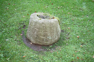
I visited Singleton, almost by accident. I was on the way to Poulton from St Annes. I could see the church in the distance off the road. Turned right off the main road, the church is 300 yards from the turn. 2 lych gates and a carpark. Entered the church did the photography and chatted to the lady outside. There is always a hesitant moment whilst they try and figure out what you are up to! However my eye caught this object by the entrance. She told me it was a birdbath!

The link to the memorials in the church is here.There is a further link to the church and other views of Singleton here

However I said I was fairly confident that it was the remains of a socket for a cross. It had seemed that this was originally down the road, probably at the cross roads. At the time I did feel I had stumbled onto something quite unusual. I have crosses on this blog. However it seems that English Heritage have a record and it was sited in the churchyard at least in 1957. Here is the link to English Heritage.
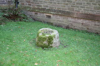
Taken from the pathway as you enter the church.
The object is approx 18 inches across and about 12 inches high

It is clear that there is a rectangular post hole in the middle of this pedestal

There are 8 clearly defined sides to the pedestal.
The pedestal is "worn" or broken on one side.
Further investigation would possibly show the reason

I would suspect that this pedestal would be sitting on more
stonework. Any sizable cross would be unbalanced.
Difficult to see if the hole went through to the bottom.

There are other wayside crosses in the area, notably at Wrea Green.
The Northern Antiquarian Forum is a fascinating place for these objects. These pix and reference will be referred to them.


Saturday, 22 October 2011

Lighteach

Another sad sight! Maybe this grand old house will be demolished by November. Looks pretty desolate. Bricks are sound - but its too late... Going to be demolished and Granny flats put up in its place or so I presume. ....Aaaagh...

From the main coast road


Lighteach

From the Moorings

From "The Moorings" drive
This house situated by "The Moorings" rest home on the promenade route to Blackpool. Just to the north of St Annes pier. There are some very fine houses here. I rented a flat in one in the late '60's. Sand got everywhere and it was really draughty. Sealed all the windows up with parcel tape. Good days! I may update the site when it has gone.


The final picture!

Only the gateposts left!

Sunday, 16 October 2011

St Cuthberts Church sundial

 Just to the South door of St Cuthbert's Church is a Sundial. The pedestal is sandstone. On top the plate and the gnomon - pointer to you and me are made of copper. There seems to have been an attenpt to remove the actual plate judging by the bends in it. It has not been cleaned for ages. This possibly preserves it. However it has been given a grade 2 by English Heritage. The plate is inscribed with "DUM SPECTAS FUGIO"  means  "I flee even as you observe me" bit of a giveaway pointing it towards the 18th Century.
St Cuthberts Sundial
This view is due south from the sundial, to the lych gate and straight down to the seafront and onto the River Ribble estuary
There are some interesting objects in this vicinity but the church is named after St Cuthbert. There is a link here.